Precision is no longer an added value — it is a requirement. In sectors where a single error can halt a critical operation, generate million-dollar losses, or compromise safety, data quality becomes the difference between reacting and anticipating. This is where the LiDAR sensor changes the rules: it turns territory into reliable information for technical and strategic decision-making.
At SIGLA, we do not use LiDAR to “measure”: we use it to ensure operational continuity, reduce uncertainty, and improve project profitability.
What is the LiDAR sensor, and why does it transform decision-making?
The LiDAR sensor emits laser pulses toward the environment and measures the time they take to return. This allows the creation of three-dimensional point clouds that represent physical space with centimetric precision. But what matters is not how it works — but what it enables:
- designing infrastructure with zero tolerance for error,
- anticipating failures before they turn into emergencies,
- planning maintenance based on real conditions,
- modelling scenarios and risks with technical evidence.
The value of LiDAR is not in the laser — it is in the decision it allows you to make.

From point cloud to decisions: the process that matters
LiDAR generates millions of measurements per second. For this information to become operational, it must go through a rigorous process:
- Multisensor capture: LiDAR + photogrammetry + GNSS + IMU
- SIGLA quality control: calibration, consistency checks, noise removal
- Processing and modelling: DEM/DTM, meshes, profiles, 3D models
- Integration: GIS, CAD, BIM, digital twins
- Analysis: technical reports, risk detection, simulations
At SIGLA, this pipeline is standardized to ensure traceability, repeatability, and precision, regardless of the project type or environment.

LiDAR platforms: choosing the right one based on risk and objectives
The LiDAR sensor can be deployed on different platforms depending on operational needs:
Aerial LiDAR (drone or aircraft)
For large areas, remote regions, power corridors, pipelines, and projects with difficult access.
Terrestrial static LiDAR
Ideal for civil engineering, architecture, tunnels, critical infrastructure, and heritage. Captures fine details with millimetric fidelity.
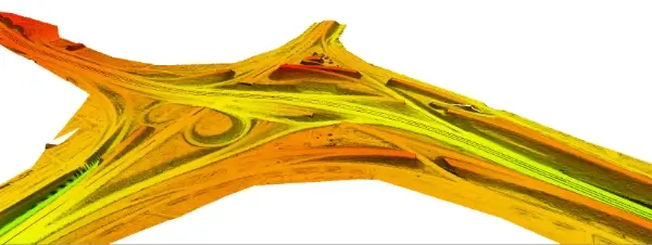
Mobile LiDAR (vehicle-based)
The standard for roads, railways, and cities. Enables continuous and efficient corridor mapping.
Satellite LiDAR
For large-scale monitoring, environmental change analysis, and territorial planning.
Choosing the right platform is not about the tool — it is about operational risk, the required level of detail, and the impact of the final decision.

Strategic applications: where LiDAR truly matters
The advantage of LiDAR is not only precision — it is its ability to solve complex problems with geometric evidence.
Advanced topography and cartography
For projects where every centimetre matters and the geometric base must be impeccable.
Infrastructure and construction
Construction control, design verification, volume estimation, early deviation detection.
Energy and utilities
Inspection of power lines, pipelines, networks, and critical assets requiring operational continuity.
Mobility and autonomous vehicles
Obstacle detection and real-time environmental modelling.
Environmental and natural resource management
Monitoring erosion, riverbeds, biomass, ecosystem changes.
Operational digital twins
Intelligent 3D models for simulation, planning, and risk anticipation.
Advantages that directly impact the business
LiDAR delivers measurable benefits:
- Reduced non-productive time (NPT)
- Minimization of operational errors
- Planning based on real data
- Optimized resources and maintenance
- Greater safety and reduced human risk
It is a strategic investment, not a technological cost.

LiDAR at SIGLA: more than data — decisions
SIGLA’s strength is not in the sensor, but in the process:
- proprietary QA/QC protocols,
- true multisensor integration,
- advanced processing aligned with international standards,
- experience in complex energy, infrastructure, and territorial projects,
- reports and analyses designed to facilitate operational decisions.
We turn millions of points into clear, actionable, and reliable information.
Trends: toward integrated geointelligence
LiDAR continues to evolve into more efficient and accessible systems, but the true transformation will come from its integration with:
- AI for automatic analysis,
- IoT for continuous monitoring,
- digital twins for simulation,
- real-time multisensor ecosystems.
SIGLA is positioned to lead this change — not only with tools, but with criteria and methodology.
LiDAR for strategic decisions: transform your projects with reliable evidence
If your organization operates in energy, infrastructure, territory, or any sector where data defines success, LiDAR is an essential ally. But without a robust process, sensor precision is not enough.
At SIGLA, we help you convert geospatial information into decisions that reduce risk, optimize resources, and ensure operational continuity.
👉 Contact our team to learn how SIGLA turns data into decisions.